Unitree 4D LiDAR L2 – 360° High-Precision SLAM Sensor for Robotics & Autonomous Navigation
Next-Generation 4D LiDAR for Intelligent Robotics
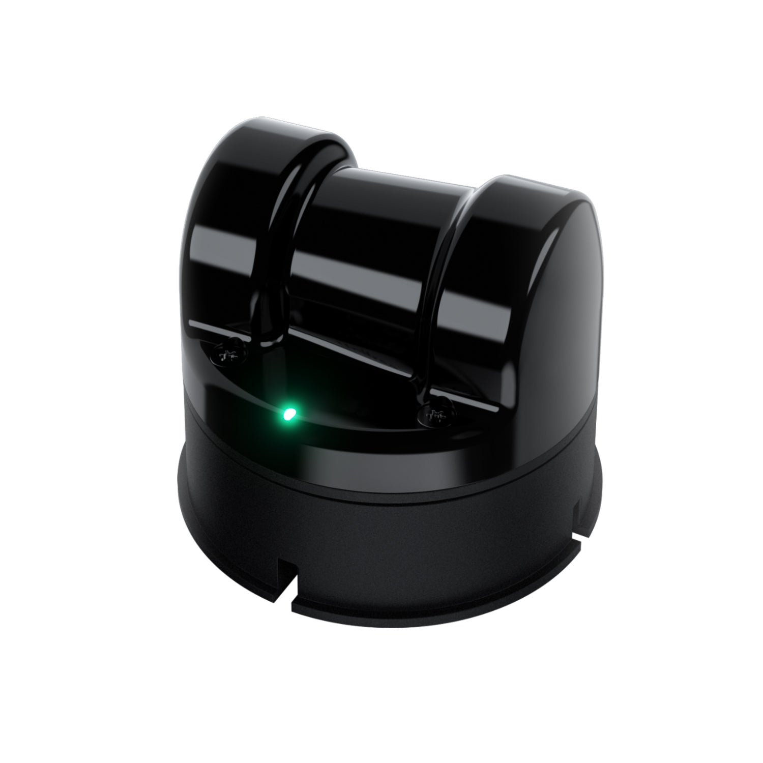
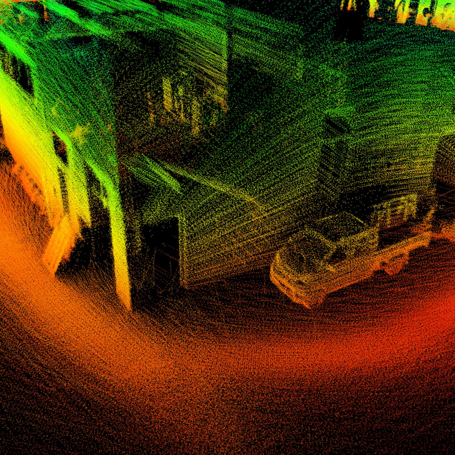
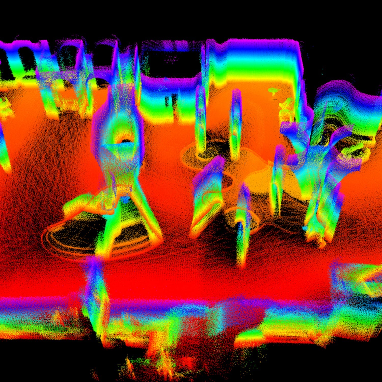
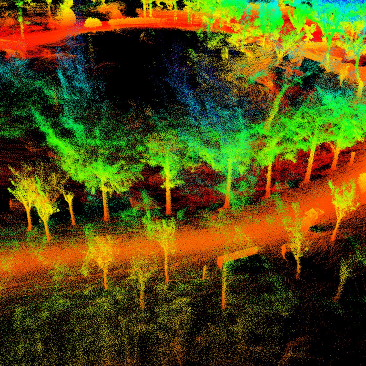
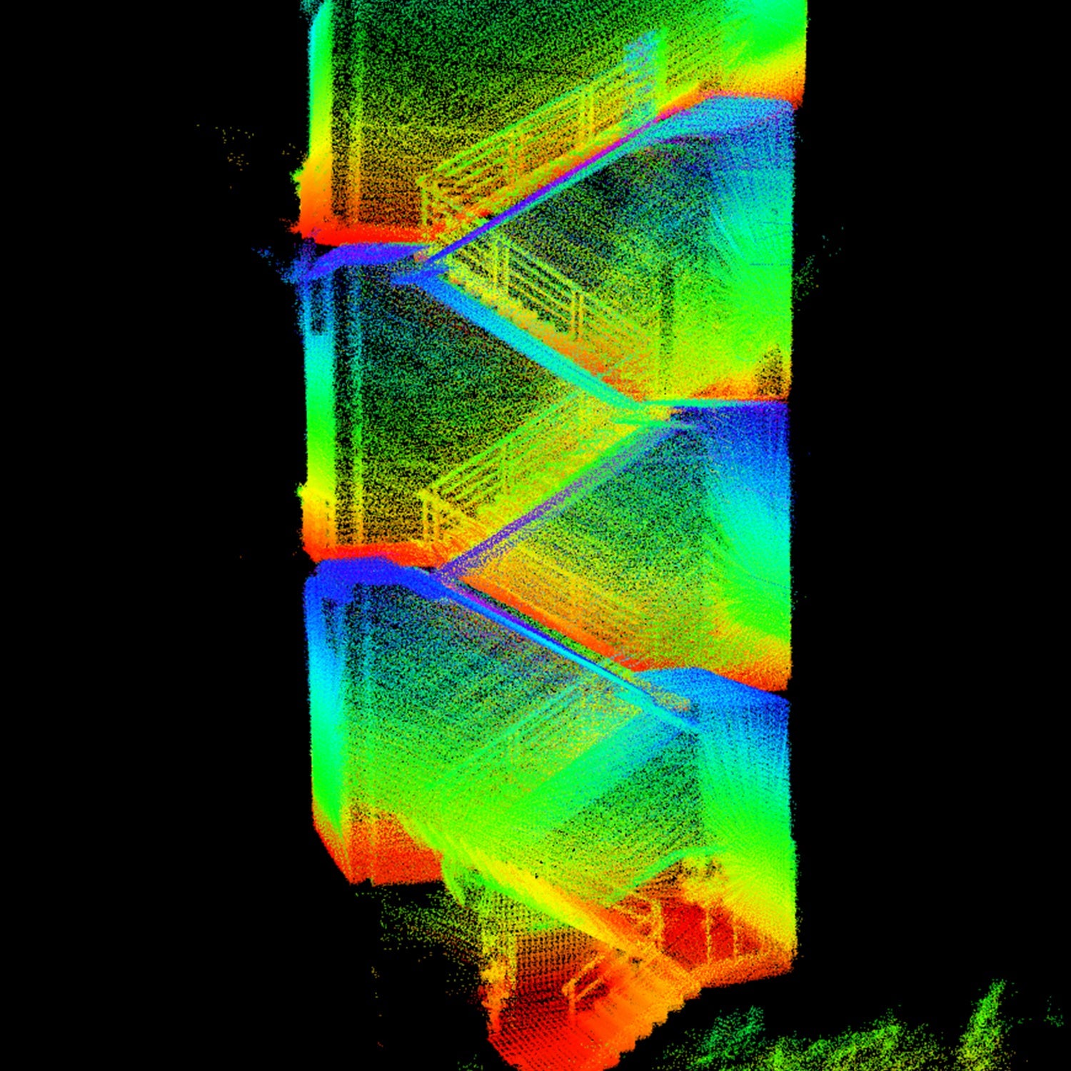
The Unitree 4D LiDAR L2 is a cutting-edge laser sensing solution engineered for robot navigation, SLAM mapping, and autonomous systems. Featuring ultra-wide 360°×96° scanning and high-density point cloud output, this compact LiDAR delivers precise environmental perception for modern robotics applications.
With a built-in IMU and support for open-source SLAM algorithms (POINT-LIO), the L2 enables developers to achieve accurate localization and mapping without relying on additional sensors.
Designed for robotics engineers, AI developers, and automation integrators, the L2 combines performance, efficiency, and ease of integration—making it an ideal sensing solution for both indoor and outdoor robotic platforms.
Key Features
360° Ultra-Wide Field of View
Full 360° × 96° scanning coverage ensures complete environmental awareness with no blind spots for advanced navigation.
High-Precision Mapping
Achieves ≤2 cm measurement accuracy with dense point cloud data for reliable SLAM and obstacle detection.
High-Density Point Cloud Output
Generates up to 64,000 points per second, enabling real-time environment reconstruction and dynamic tracking.
Built-in IMU for Sensor Fusion
Integrated 3-axis accelerometer + gyroscope supports stable motion tracking and improved mapping performance.
Strong Anti-Interference Capability
Performs reliably under strong outdoor light (up to 100,000 lux) and complex indoor environments.
Compact & Lightweight Design
Weighing only ~230 g, the L2 is ideal for mobile robots, drones, and embedded robotics systems.
Why Choose Unitree L2 LiDAR
Unlike traditional depth cameras or basic LiDAR systems, the L2 offers:
- True 4D perception (3D position + intensity data)
- Ultra-wide omnidirectional scanning
- Minimal blind spot (0.05 m) for close-range detection
- Low CPU consumption, reducing system load
- Seamless compatibility with robot SLAM frameworks
This makes it a powerful and cost-efficient solution for developers building autonomous robots and AI-driven systems.
Technical Specifications
| Parameter | Specification |
|---|---|
| Model | L2 |
| Technology | Laser TOF (4D LiDAR) |
| Field of View | 360° × 96° |
| Range | Up to 30 m (@90% reflectivity) |
| Measurement Accuracy | ≤ 2 cm |
| Point Cloud Rate | 64,000 points/s |
| Distance Resolution | 4.5 mm |
| Blind Spot | 0.05 m |
| IMU | 3-axis accel + gyroscope |
| Communication | Ethernet (UDP), TTL UART |
| Power | ~10 W |
| Weight | ~230 g |
| Size | 75 × 75 × 65 mm |
Applications
Mobile Robot Navigation
Accurate localization and obstacle avoidance for quadrupeds, AGVs, and service robots
SLAM & AI Mapping
Ideal for ROS / SLAM development, autonomous navigation, and environment modeling
Logistics & Warehousing
Supports intelligent delivery robots and automated warehouse systems
Industrial Automation
Used in smart factories, inspection robots, and autonomous systems
Smart Robotics
Enables advanced features in cleaning robots and service robotics
What’s Included
- 1 × Unitree 4D LiDAR L2
- Communication interface cables
- Mounting support
- Technical documentation / SDK